3D Laser Scanning Services in San Francisco, California
Leading Provider of 3D Laser Scanning Services in San Francisco, CA
Arrival 3D is the trusted leader in 3D laser scanning services in San Francisco, California, and a nationwide provider of high-accuracy LiDAR and scan-to-BIM solutions.
With over 20 years of experience, we help architecture, engineering, and construction professionals capture precise as-built conditions—documenting every structural, architectural, MEP feature, and concrete reinforcement using advanced terrestrial laser scanners.
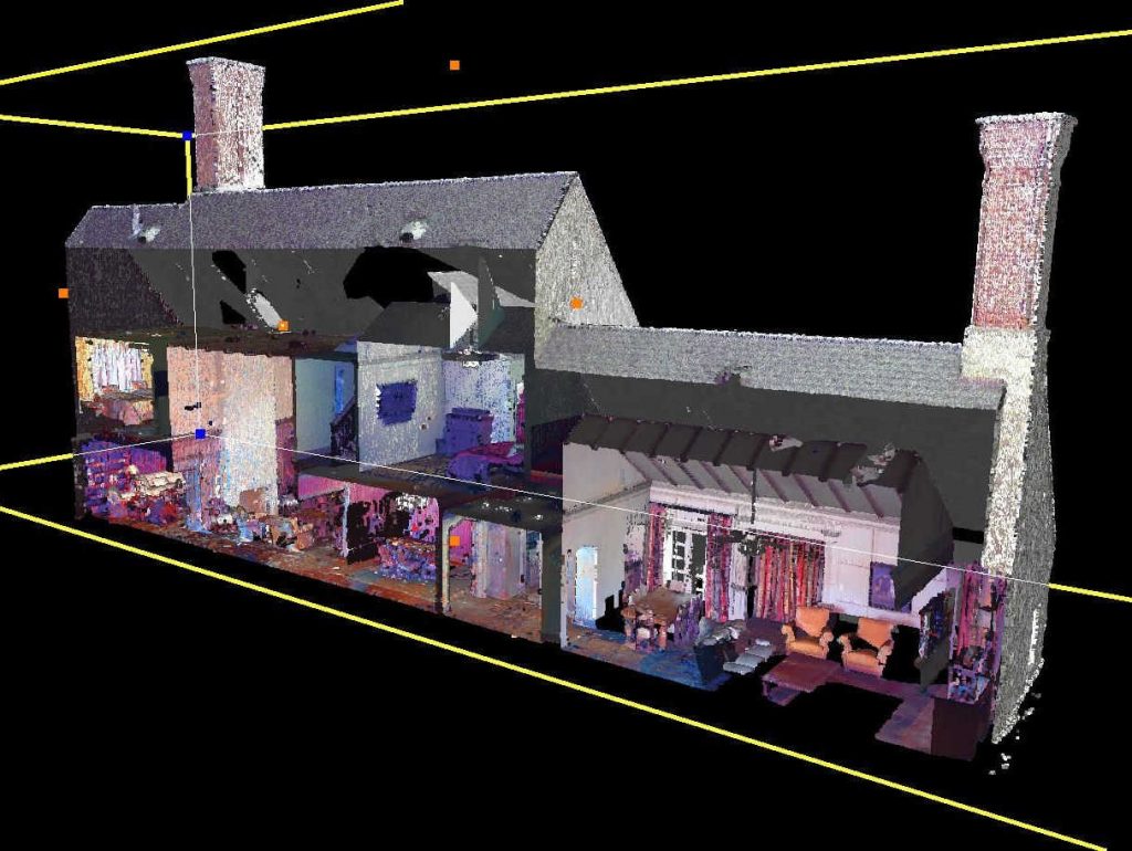
Our expert team transforms point clouds into floor plans, 2D CAD drawings, 3D BIM models, and digital twins, enabling smarter planning and execution across construction, manufacturing, oil & gas, and facility management.
Proudly serving clients nationwide, including locally in San Francisco, Arrival 3D delivers fast, reliable, and high-resolution digital data for projects of any size.
We’ll contact you to discuss your project’s goals, timing, and any existing documentation such as CAD files or as-builts to help us define the scope and plan the scan efficiently.
Site Access and Preparation
You give access information and safety regulations then we ensure our team is prepared to scan without affecting your production.
High-precision 3D scanning
We use modern LiDAR technology to record every feature of your site with pinpoint accuracy.
Data Processing and Modeling.
We convert raw scan data into clean point clouds, BIM models, CAD drawings and floor plans according to your specifications.
Delivery and Implementation
We deliver your finished assets on time which is ready for integration into your design, construction or facility operations.
Why is laser scanning important in San Francisco projects?
Arrival 3D is the leading provider of 3D laser scanning services in San Francisco, CA Massachusetts, delivering unmatched accuracy and expertise on every project. Our highly trained Project Managers use state-of-the-art equipment, including the Leica Scan Station P-Series and Leica RTC360 3D laser scanners, capable of capturing up to 2 million data points per second with 2–4 millimeters of precision.
In a city like San Francisco, where construction speed is fast, having accurate data saves both time and money. With ARRIVAL 3D 3D scanning
You get complete data from a single scan.
There is no need to visit the site repeatedly.
Contractors get accurate as-builts.
Coordination between design and construction is smooth.
Change orders and onsite surprises are reduced.
MEP layout and structural checks are easily done.
All this happens without any disruption—neither production nor operations.
Applications of Reality Capture in San Francisco, CA
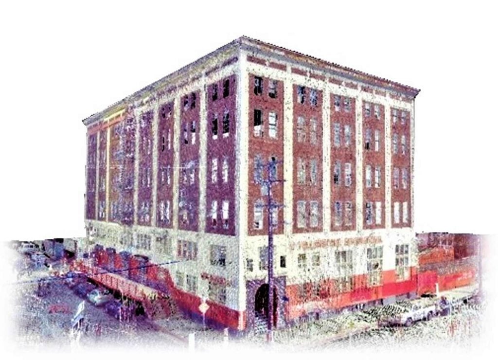
Renovating an old Multi-Story Building
When planning and engineering for multi-million dollar projects such as a large building renovation, it is critical that things go right. Boston reality capture 3D scanning up front allows engineers to draw up precise plans and drawings that minimize conflicts during construction. The scan serves as an invaluable resource for many interested parties in such a project.
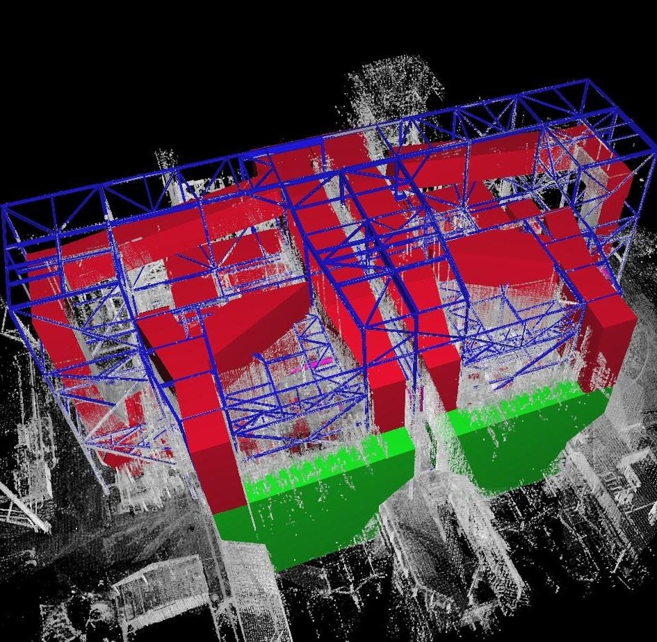
Obtain As-Built Models of a Power Plant
When planning and engineering for multi-million dollar projects such as a large building renovation, it is critical that things go right. Boston reality capture 3D scanning up front allows engineers to draw up precise plans and drawings that minimize conflicts during construction. The scan serves as an invaluable resource for many interested parties in such a project.
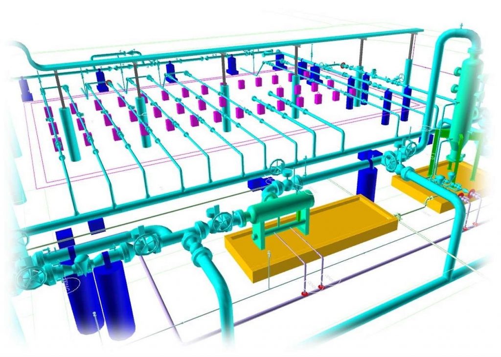
Update P& ID for a Gas Plant
A plant in the oil and gas industry will change over time, that is without question. This results in the P&ID of record ultimately becoming out of date. 3D laser scanning provides a dual benefit of not only providing a way to update P&ID’s but also provides a truly accurate as-built reference 3D model of the plant. We feel that an as-built 3D model combined with smart P&ID’s is the way of the future.
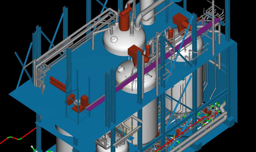
Design to Fit Existing Pipes, Vessels and Equipment
When a processing plant adds a new product line, there is new piping and equipment that needs to be installed. With careful planning and the as-built drawings obtained from doing 3D laser scanning, the new piping designs can be engineered for precise fit, minimizing installation delays due to unforeseen conflicts.
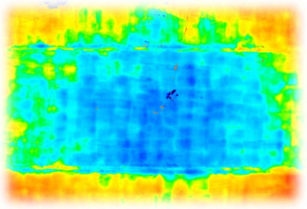
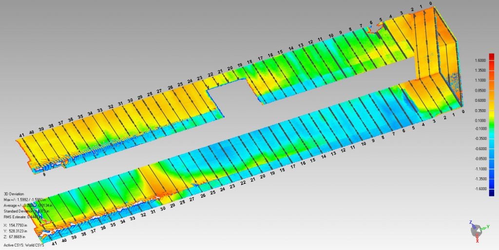
Measure Floor Flatness
3D laser scanning provides a better way of measuring and visualizing floor flatness than the old FL and FF method as measured with a ruler. When you use a 3D scanner you get extremely thorough and accurate results that can be depicted as color maps for a deep understanding of the floor’s shape.
P2D Plans for Permits
3D laser scanning is very efficient at capturing floors, walls and ceiling of building interiors as well as anything outdoors. From the scan we can quickly generate plan and elevation views that you can use as a basis for various purposes like obtaining permits.
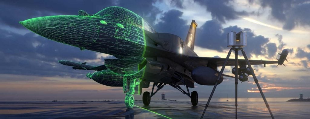
Obtain a 3D Model of an Aircraft
Scanning an airplane is a fantastic way to capture it’s shape. We can scan interior and exterior and convert it into a CAD model or STL mesh depending on your needs. From small single seaters to airliners, we are the best at aircraft 3D scanning and would be delighted to scan an aircraft for your company.
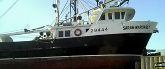
As-built reference for Boats, Ships & Vessels
3D laser scanning can capture the exterior or interior of a sea-going vessel. Any sized boat, ship or vessel can be scanned. For smaller boats (depending on location) this can be done in a day. The scan can be turned into 2D drawings for use by a naval architect, or into 3D solid models for various types of analysis.
Determine whether something will fit
You may have a pump that you need to lower into a channel, and you want to see if it will fit before lowering it in and getting stuck. Or perhaps you have a large vault door that hasn’t been opened in years, and you want to know if it will scrape the concrete. 3D scanning can answer these questions so you can proceed with confidence.
Analyze Wind Turbine Towers for Defects
Wind Turbines can be scanned safely and easily from ground level. Scans can be used to analyze and to identify any dents that may be present, and map out their location and depth. Scans can also be used to analyze the tower as a whole, and determine whether it has been structurally compromised after a failure event.
Why Choose Arrival 3D For 3D Laser Scanning in San Francisco, CA
Arrival 3D’s Laser Scanning Services bring the following benefits to your project:
Collect up to two million data points per second using survey-grade 3D laser scanners
Capture precise dimensions and spatial relationships of your site with millimeter-level accuracy
Accelerate project planning and design with highly accurate as-built documentation
Avoid costly site disruptions, rework, and unnecessary revisits
Receive detailed point clouds, 2D CAD drawings, and 3D BIM models to streamline coordination
Take a virtual tour of your scanned site, complete with measurement tools and digital annotations
Minimize risk, change orders, delays, and cost overruns with reliable, verified site data


")
")
")