Bridging the gap between art, engineering, and technology, 3D laser scanning is changing the way documentation and site details are preserved. Whether used to preserve cultural heritage or modernize infrastructure, LiDAR-based scanning has become the cornerstone of digital preservation.
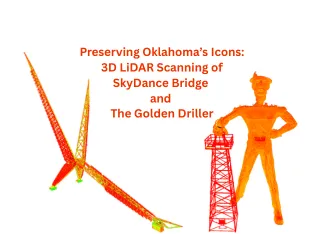
The two sites, the SkyDance Bridge in Oklahoma City and the Golden Driller in Tulsa, Oklahoma were recently scanned and digitally documented by Arrival 3D as part of its ongoing 3D Laser Scanning Projects in Oklahoma. Through advanced LiDAR and BIM integration, these projects created high-precise digital twins that support long-term preservation, maintenance planning, and even virtual engagement for future generations.
Let us understand in detail:
Preserving Oklahoma’s Icons: 3D LiDAR Scanning of SkyDance Bridge and The Golden Driller
Arrival 3D specializes in 3D laser scanning, BIM (Building Information Modelling), and as-built documentation using LiDAR (Light Detection and Ranging) technology, and more. The company was commissioned to scan two iconic Oklahoma structures – Skydance Bridge in Oklahoma City and the Golden Driller in Tulsa; each required millimeter-accurate 3D data for restoration, engineering validation, and historical preservation.
- Skydance Bridge – Required full digital documentation of its intricate steel geometry for long-term archiving.
- Golden Driller – Required high-resolution LiDAR scanning for digital preservation, structural analysis, and VR integration.
Project Highlights:
Here are the project details for two locations handled by Arrival 3D:

- Location: Downtown Oklahoma City, across Interstate 40
- Completion Year: 2012
- Designers: Hans Butzer and Stan Carroll
- Structure: 380-foot-long pedestrian bridge inspired by Oklahoma’s state bird, the scissor-tailed flycatcher
- Objective: Digitally capture the bridge’s complex steel framework so designers can document, visualize, and preserve it long-term.
2. The Golden Driller – Tulsa

Here are the project details of The Golden Driller:
- Location: Tulsa Expo Centre, Tulsa, Oklahoma
- Installed: 1966 (originally built in 1953)
- Height: 75 feet (23 meters)
- Material: Steel frame covered with concrete and plaster
- Objective: Use high-resolution LiDAR scanning to help preserve Tulsa’s historic monuments through digital archiving, maintenance, and VR experiences.
Tools and Equipment Used
Arrival 3D utilized high-precision LiDAR scanners and industry-leading software to ensure sub-millimeter accuracy:
- Leica RTC360 : High-speed LiDAR scanners capable of capturing millions of 3D data points per second with sub-millimeter accuracy.
- Cyclone REGISTER 360: Used for point cloud registration and alignment to create unified 3D datasets. The data points captured with the scanner are used here for the registration to ensure high accuracy.
- Revit & AutoCAD: Software platforms for converting point clouds into 3D BIM models (Scan-to-BIM) and CAD drawings for analysis and visualization. These software are mainly used for converting into 3D models; they use data points for development.
Workflow: Steps for 3D laser Scanning for Projects
Here are the steps taken for 3D reality capture or scanning for projects by Arrival 3D:
- Planning and site preparation: Projects start by defining scope and requirements. The team identifies scan areas using scanners or drones. They assess the site for environmental, safety, and lighting needs to plan equipment and installation. The early preparation of these sites, including scheduling, areas of installation, and more, helps in successful projects.
- Equipment set up and data capture: The team installs scanners like LiDAR scanners, drones, and more. These scanners capture millions of data points using laser sensor points, producing dense data point clouds. The skydance bridge scanning was captured using curved beams and suspended deck structures. The golden driller records the texture of concrete, folds, surface weathering, and detailed traditional photography. Using these scanned data points, the software develops digital models later for maintenance and upgrades.
- Point Cloud Registration: The data captured from scanners requires point cloud registration, which is the process of aligning multiple scans into one coherent set. After point cloud registration, Cyclone REGISTER 360 is used to align these points, which helps in forming a 3D model. The registration process improves geometric continuity and produces millimeter-level precision in capturing.
- Conversion for BIM and CAD: Using the data transferred into software, the data is converted into BIM (Building Information Modeling). The data is imported into Revit and AutoCAD, which is then used for 3D digital models for visualization, maintenance, and planning. The final deliverables of the project include digital twins (virtual replicas of the physical structures) that can be used for structural reviews, lighting design simulations, or virtual tours.
What are the challenges faced during the scanning process?
Here are some of the challenges that are faced during the scanning process:
- Complex areas for scanning: A major challenge was scanning the complex curves and steel angles of Skydance Bridge, making visibility and point continuity difficult. The team faced overlap and scanner setup challenges.
Solution: The team supervised every section during installation and scanning to ensure all the areas were covered.
- Environmental Conditions: Weather and lighting made scanning elevated platforms and certain areas difficult. The team faced challenges working around these conditions.
Solution: To make it easy and feasible, ensuring equipment is used in the best way while maintaining safety protocols, the team makes a scheduled scan with buffer timing. The scanning was scheduled while keeping environmental conditions in mind.
- Scalability and Accessibility: For the Golden Driller, the sheer height and location near public areas made positioning equipment difficult. The team has to take additional efforts in accessing a few sections of the structure.
Solution: Scanners were mounted on extendable tripods and aerial lifts to cover all angles safely.
Results and Benefits
Here are the results and benefits of both projects:
For the SkyDance Bridge
These are the results and benefits of scanning for Skydance Bridge:
- Preservation: Created a lasting digital record of Oklahoma’s architectural landmark.
- Engineering Validation: Enabled monitoring of potential steel deflection and alignment changes over time.
- Lighting Design: The 3D model supported simulation of the bridge’s programmable LED lighting, allowing designers to test colour patterns virtually.
- Public Engagement: Produced high-quality visuals for virtual tours and educational exhibitions.
For the Golden Driller
These are the results and benefits of the Golden Driller Bridge:
- Digital Preservation: Ensured accurate as-built documentation against wear and tear or future restoration needs.
- Structural Analysis: Provided precise measurements for engineers to evaluate stability and surface conditions.
- Tourism & VR Integration: Allowed Tulsa’s cultural institutions to showcase the statue in immersive 3D experiences.
- Historical Continuity: Preserved the legacy as part of the digital heritage initiatives.
Conclusion
Both the SkyDance bridge and the Golden Driller represent Oklahoma’s artistic and cultural identity structures that deserve lasting preservation.
These are important to preserve and restore for legacy and future generations. Arrival 3D created detailed digital twins that help engineers, architects, and historians maintain these icons safely and accurately. These digital models are then used for upgrading the sites, maintaining them, and ensuring the building and bridge do not lose their strength over time. The 3D scanning helps with as-built documentation, capturing data that helps engineers, facility managers, and architects. As technology continues to evolve, projects like these demonstrate that even historical monuments can benefit from advanced digital preservation methods.