Over 30,000 Miles of sites scanned
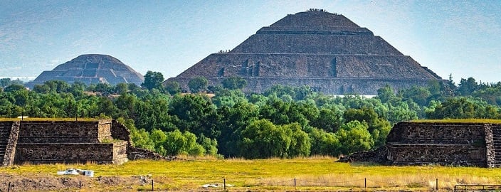
Creating 3D maps is easier than ever before with the help of 3D laser scanning services. A team of archeologists made it their mission to scan over 30,000 miles of Mesoamerican sites with this technology. They used technology to acquire never before seen information from pre-colonial towns in Mexico. From 3D laser scanning services, they could determine how a settlement was created, founded, and details that connected them to the MesoAmerican calendar.
3D laser scanning services can hold tons of information and filter through images and cloud points rapidly. That is why the architects chose this technology to gather information on over 478 sites. They also found that some of these sites were constructed around 1400 BCE to 1000 CE. Through 3D laser scanning services, they believe that the architecture was done on purpose to help create a symbolic reference to other surrounding things like the sun and the mountains.
The teams were able to categorize the sites into five areas from different time periods of when they were built. One of the challenges of this mapping project was finding the hidden structures within the cities. The great news about 3D laser scanning services is that they can be attached to a drone or other moving mobile to capture more details from other angles. This technology can capture the hidden areas from above that can help the team investigate more thoroughly.
3D Laser Scanning Services Is A Revolutionary Technology
This technology is revolutionary for archeologists. Typically it would take months or even years to find hidden sites or structures. It takes long hours to excavate one site, but with the help of 3D laser scanning services, they can map out an entire site right down to the microscopic level. It allows them to see what no one else has ever seen before.
What did they use?
3D laser scanning services can use LIDAR or light detection and range. A laser beam shines over an area’s surface, and the machine is measured by how far that beam travels. When it takes longer to get back to the machine, that’s how the team knows there is something to check out in that area.
On top of that, it records things quickly then saves the information in a partnering program. Architects can sort through the details and images and then edit them to make a digital version. It means that even when they are not at the physical site, they can view all the details as if they were there.