3D Laser Scanning services Unveils some secrets
Some ancient Roman roads may have been discovered in northern England that had gone unnoticed for centuries. Thanks to some use of a 3D laser scanning services technology called lidar, parts of the old road may have been seen over head. The agency in charge over the United Kingdom’s environment has been scanning the region for almost two decades using the technology.
3D Scanning through the trees
They have been gathering data about the nation’s land. Lidar works by shooting laser pulses that reflect off of the surface back to the scanner allowing them to create a 3D image of the layout of the land. The 3D image shows the contour of the land because it can pierce through all of the trees, bushes, and other greenery. The main reason for this scanning operation is so they can track corrosion and strategize for protecting crops. After they collected all of that data, it was made available to be analyzed.
Dots connected by 3D laser scanning
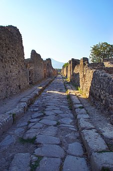
What seems to be the remains of the Roman Empire’s old road system which was uncovered by 3D laser scanning services has some ears perked. Those who are into history and love archaeology are especially interested to look into it further. It is hard to imagine that Britain was occupied by the Roman’s in the first century. In order to keep under their control they had to built some road that connected to Britain. It is really a rarity to find undiscovered Roman roads in this day and age. There are still a few stone sections of the road to see, but the rest, for the most part, have been destroyed or built over by farmland.
It all makes sense now
In fact, the remains of history have left some unsolved mysteries about the road that reached into Britain. Some have always wondered about the route that went from Lancaster to Ribchester. It has puzzled some to know where the route was. This is why this 3D laser scanning services discovery is so interesting to history lovers. The routes that were discovered by lidar technology may have just answered that question. There is an 11 mile path that shows the way that they went from Ribchester to Catterall, and then on to Lancaster. It all makes sense now that they have discovered the route. The most profitable route would have been through Catterall. Now that they see it, it is hard to imagine how they could have missed it.
3D Laser scanning is a cool tool
It is pretty amazing what 3D laser scanning services using liar technology can do. Not only have they found missing links to the Roman road, but NASA is even using it to collect data about the surface of the moon. It has also been utilized to help with disaster relief. For example in Haiti, in 2010, the earthquake that hit was devastating. Lidar was used to help assess the damage. The same is true for hurricane Sandy.
There are, of course, lots of other ways that 3D laser scanning services are being used to analyze the surface of the ground and help solve problems. The Roman road discovery is just one among many more discoveries to be found.