A dangerous job needs 3D Scanning services
Surveying can be dangerous work, especially if it involves underground open spaces. There have been numerous instances of roofs collapsing, trapping people inside and crushing them to death. This happened in Bhutan at a hydroelectric dam. The main area of access collapsed, slowing down the project work considerably. When a section of tunnel collapsed underground, no one can proceed until they can guarantee the safety of the area. They have to go in and measure the size of the cave after the collapse and get an idea how much rubble is needed to be removed. In order to get this information, an Indian company applied 3D scanning services, and found out the measurements of the underground cavity and how much debris needed to be removed.
More than meets the eye
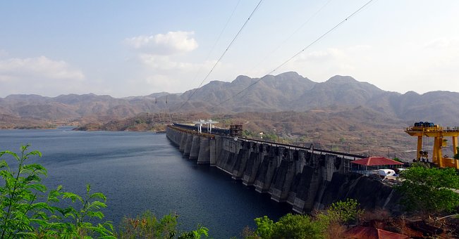
The hydroelectric project was started by both the government of Bhutan and Indian working together in an area along one of Bhutan’s rivers as a means of producing some electricity to some homes in both countries. One part of the project was to build a dam of over 80 meters high, and over 210 meters wide. The dam, of course, is not just a big wall that get plopped into the ground. There is much more to it that is unseen. Along with the dam itself are a whole bunch of tunnels, chambers, shafts, and a power station.
Finding the right tools with 3D scanning services
While digging out one of the chambers, one of the roofs caved in the main tunnel. This caused a complete stand-still because of the blockage. The site had to be evaluated before things could move forward. Those in charge over the project wanted to go in and get some exact measurements of the collapsed cavity. They needed those measurements to help them decide whether the construction site was safe enough to send people in or not. 3D scanning services was the tool that they used to get the measurements. Those measurements would also give them information about the pile of rubble. They had to proceed forward as carefully as possible. Some lives had already been lost. There was no need to lose even more.
3D Scanning gathers the data
The process of evaluating the situation began, and they came up with some key information to change the way they could survey the underground cavity. They bore down into the ground and came to find out that the area was too deep underground to be able to use radar technology. What they did was lower in a 3D scanning service device that could gather data on the dimensions of the cavity. Once the data was captured, they lifted out the device. They could then transfer that data onto computer to do a thorough analysis.
3D scanning services turned out to be an effective and safe way to get the information needed to determine the conditions and the risks of further excavating the tunnels. Thankfully, they were able to do that. This is just one example of how 3D scanning services is helping people do job more effectively and much safer.