3D Scanning Services make use of time-of-flight scanning
What laser pulse-based 3D laser scanning services is able to accomplish is nothing short of incredible, and also exciting for a number of intriguing reasons that are related to its capacity to reality capture of the tiniest details of what it is faced with. This bodes well for a number of professions and projects, particularly for those who are involved in construction and architecture and/or have certain degree of appreciation for it.
The reason for this is that it is able to scan objects at a truly large scale and even what are referred to as environments. It can be used to construct a 3D map of an entire area, certainly no small feat, and one that carries with it all sorts of mind expanding implications and opens the door to a new era of mapping. For example, if you wanted to you could have the Louvre museum scanned and then have yourself a smaller scale representation of it printed out that you can place in your living room as a decorative piece. The fine detail would be sure leave all visitors impressed.
This is the most impressive thing about it, especially when one makes comparisons to other types of 3D laser scanning methods that are out there, the scale, you can take things that are of great size and upload it into an imaging program to do with as you please. 3D laser scanning services hasn’t been thought of in this way as the resolution that is involved in accomplishing it would have to be quite great in order for one to have an image map that doesn’t have blotches or erroneous pixels all about.
This last part simply can’t be overstated as there is a considerable superiority in this regard when Laser Pulse, or Time-of-Flight scanners as they’re also known, are measured up to other types of 3D laser scanning services. It’s a pretty ingenious system that works by emitting laser beams and measuring the time and the angle sensed when they bounce back from a target.
The degree of precision is truly remarkable and there are many applications for those that are involved in the construction business. This includes breaking down steel and piping models for instance as they need to be accurately determined when you’re working out the dimensions and the contours that are in play to make the final product cohesive. There’s a lot that’s possible when the distances of millions of laser pulses can be measured to reality capture truly acute detail. It has already made large scale public private works so much more efficient and exact to both plan and carry out.
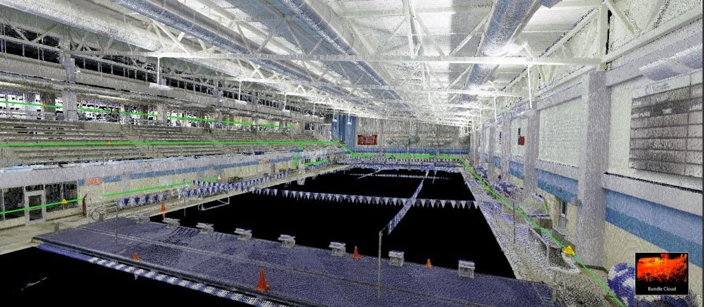
If you’re more familiar with smaller 3D scanning services such as those that are handheld you should check out the different ways that Laser Pulse scanning is used with respect to terrestrial LIDAR. LIDAR stand for light detection and ranging, and is a remote sensing method that uses these mentioned laser pulses to collect with astonishing detail millions of measurable survey points in just a matter of minutes. And despite being quite fast and being applied to a rather broad area, it doesn’t disappoint with its accuracy.
One of the biggest advantages to using the LIDAR system is that it can be used to survey all kinds of environments including those that would be deemed too dangerous to be surveyed by more conventional methods that have been used in the past. It’s an unparalleled degree of documentation that is providing scientists of a plethora of important disciplines with invaluable information about the state of the natural world that surrounds us. It has also been found to be absolutely critical when carrying out forensic investigations.
Point cloud data that’s gathered through LIDAR processes can give us all kinds of important spatial coordinate data that we didn’t have before and is providing us with a greater wealth of knowledge that just keeps adding up. From analyzing ancient ruins to pinpointing the makeup of natural wonders, it is serving mankind as a way to record and really provide us with a much better rounded sense of identity. We are now able to actually record the actual shape of the earth, and to this end it is a pretty noble accomplishment as we will fairly soon be able to go online and view a3D cloud point map of the world. As such there are many possibilities that are sure to come along. If you wanted to see a landmark up close, even if it’s just though a computer screen, you can do so, and if you so wish you could take the extra step of printing out a 3D model of your favorite natural landscapes.
The implications for educational purposes are quite considerable and something that students and teachers should have the right to access. When you can hold natural formations that are found thousands of miles away right in your hands, as someone learning about the world, you can feel more engaged and as though you can actually feel and interact with what’s being discussed.
The key word is resolution, as this isn’t at all an easy thing to acquire to a high degree when you’re talking about what lies on the other side of the front door. As this technology becomes more widely available and used we can look forward to becoming accustomed to a greater understanding of what the make-up of the most distinguishing features of the planet are. For many it’s seen as a long time coming and we should make the effort to acquaint ourselves as much possible to 3D imaging software so that we can, on a personal level, engage with the world at large and in doing so, broaden our horizons.
Laser pulse hasn’t been at all easy to develop and represents a great leap in 3D scanning services, however it has certainly been worth the wait as it is sure to contribute to a construction of a brighter and better defined understanding of what makes up our environment and the things that surround us, how they really are. It is indispensable in advancing scientific endeavors and we should feel proud but more than anything willing to contribute ideas about how best to exploit it.
There are many cases where such a high level of 3D laser scanning services is bringing the world closer to those that inhabit it. It will be interesting to see in the coming years how the influence of this technology manifests itself in society going forward, but one thing is for sure, it is opening up all sorts of
possibilities.
For many people it is allowing them to have a better defined understanding of the make up of many of the remotest environments, and for professionals in construction it is making the process building more of an art and even an exact science, than we have ever seen before.