3D Laser Scanning shows you the way home
I remember the time I got lost in a big city. I had just moved there and was not very familiar with the streets. On top of that, I couldn’t see the sun because of the clouds that day. It was a Saturday and I was kind of bored. So what I did was I hopped on my bike and just headed out to explore. I grabbed some snacks and threw them in a backpack and just started petaling on my bike. As I rode, I took no care for where I was. After about thirty minutes I had no idea where I was. I was lost. Eventually I found my way back after asking for some directions. Some people similar to me like doing that but, not everybody is excited about getting lost. Some people start to freak out when they get a little turned around. For this reason, it is a good idea for them to have a good map. A big city needs a good map out of everything. This is where 3D laser scanning services comes into play.
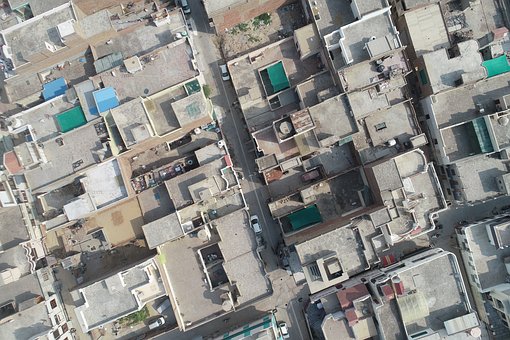
Maps made with LIDAR technology
Several years ago, If you lived in New York, then you might have heard noise above your head in the early morning. You just might be hearing those 3D laser scanning services guys going about a mapping project of the entire city. The technology that they used to gather data for the highly detailed map was a light detection and ranging technology called LiDAR. LiDAR works similarly to a radar, except that it doesn’t use sound as its medium of measurement. This technology uses reflected light as a means to measure distance. From high up in the sky pulses from a laser are sent out, and as they are reflected back, sensors measure the distances of those pulses travelled. Many of these distances together can be a point of location. When many of these location points are put together, they form a 3D virtual image of the surroundings. The final result can be a highly detail map of the terrain of the city.
Advantages of 3D laser scanning maps
So what would be the advantage of having a map like that? All I have to do is ask around a little bit to find my way around the streets. First of all, a highly detailed map of any city would be a cool enough reason to have it. Secondly, it would help the city with urban planning. A good map of the city will tell them a lot about population density and where and which directions to expand. It can also provide emergency crews the means to plan for escape routes in case there is some disaster. All of these could be better assessed with a highly detailed map made by 3D laser scanning services.
It is amazing what can be done at several thousand feet above ground when using 3D laser scanning services. A highly detailed map may seem insignificant to us who already know the cities we live in well. Yet, there are a lot of things that can be done with it that we probably don’t realize.