Building Information Model

Real Estate Laser Scanning Services

High-Precision 3D Scanning

Welcome to our Real Estate Laser Scanning Services. We provide high-precision 3D laser scanning solutions tailored for real estate professionals, architects, developers, and property managers. Our cutting-edge technology ensures accurate and detailed digital representations of properties, helping streamline documentation, design, and project planning.

Looking for accurate 3D scanning services for real estate properties? Our advanced scanning technology captures detailed data to improve property management, renovations, and architectural planning.

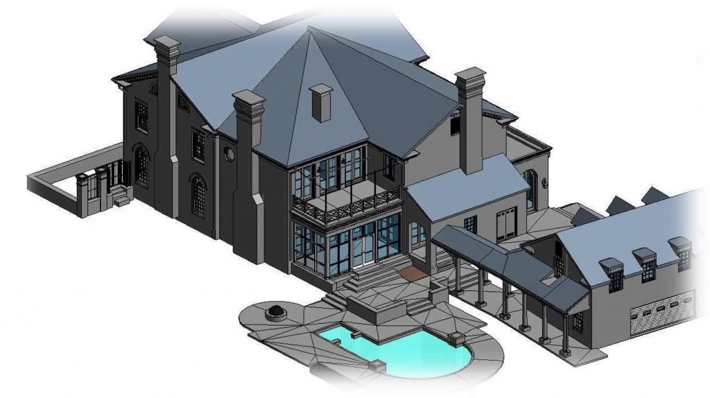
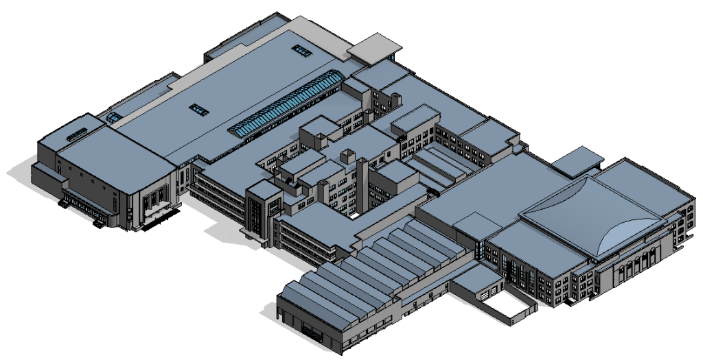
Real estate laser scanning provides precise measurements of buildings, interiors, and landscapes. This data supports architectural design, space planning, and property documentation, ensuring accurate records for various applications.

Let us scan your project

"*" indicates required fields

Drop files here or
Max. file size: 256 MB, Max. files: 10.
    Opt-In
    By providing your consent, you agree to the Arrival 3D Privacy Policy and Terms & Conditions . You also agree that Arrival 3D may contact you via email, phone, or text message, which may involve the use of automated means. Message/data rates may apply.
    Hidden
    Hidden

    Our Services

    Real State Lidar Scanning Services

    We offer a range of laser scanning services for real estate, including:

    • 3D Property Scanning – High-resolution scans to create digital twins of buildings.

    • BIM & CAD Integration – Convert scanned data into Building Information Models (BIM) and CAD files.

    • Floor Plan Generation – Accurate floor plans derived from laser scans.

    • As-Built Documentation – Comprehensive as-built records for renovations and property assessments.

    • Virtual Tours & Walkthroughs – Immersive 3D visualizations for real estate marketing.

    • Structural Analysis & Inspections – Detect structural concerns with precision.

    • Space Planning & Interior Design – Optimize designs with accurate floor plans.

    home 3D scanning services
    person with laser scanner
    Real estate Lidar Scan

    Consider the cost of Real Estate Scanning

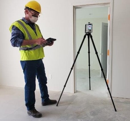
    If you want to take your own pictures, you can be expecting to buy some of these tools:

    • 3D Camera – $3,000
    • 3D Laser Scanner – $30,000 – 80,000, depending on the model you choose
    • Software – $700 – $7,500 
    • Tripod – $260 – $1,500
    • Extra – $500 or more (lighting, bag,  extra batteries, memory cards)
    • Modeling software – $3,000

    It can cost up to a grand total of $30,000 or much more for a high end setup  for a 3D laser scanner and required software and accessories. Keep in mind, this would be assuming you know how to operate all of these items. If not you will need to include training. 

    Accuracy

    Why Arrival 3D is the #1 Real State Scanning Provider

    • Advanced LiDAR Technology – Utilizing top-tier LiDAR and 3D scanning equipment.

    • Expert Team – Over 10 years of experience in real estate scanning.

    • Quick Turnaround – Fast, efficient, and reliable service.

    • Customized Solutions – Tailored scanning services for your needs.

    Building 3D Laser Scanning
    3D Laser Scanning

    Industry We Serve

    Our scanning services support multiple industries, including:

    1. Commercial Real Estate – Office spaces, retail properties, and industrial sites
    2. Residential Properties – Homes, apartments, and condominiums.
    3. Historic Preservation – Document and restore heritage buildings.
    4. Construction & Architecture – Accurate as-built documentation and BIM modeling.
    5. Facility Management – Asset tracking and maintenance planning.
    Veterinary Medical Diagnostic Laboratory
    Applications

    What are the uses of Building Information Modeling?

    Building information modeling is useful for just about any project involving a building that has a construction phase. These are the “no brainer” cases, like obtaining as-built models for renovating a hotel, re-designing a hospital floor or gutting an office building. But there are other uses as well such as planning emergency exit routes and calculating space volumes for fire systems and ventilation systems. You may need to map out the water sprinkler position relative to the equipment in the room, for example.

    BIM Model Usage Over the Project Lifecycle

    The beautiful thing about having an accurate digital representation of a space is that it can be re-used by multiple stakeholders at different stages of the project. Early incorporation of bim models into the building process leads to better outcomes at the end of a project.

    Scan to BIM in the Construction Industry

    Bim makes assessing progress of construction projects much easier. It starts with collecting data using a 3D laser scanner. The point cloud is a snapshot of the construction progress. Bim enables comparison of the design model with the scan data using tools such as Autodesk Navisworks. Collecting data is getting easier as well, as modern laser scanners are faster than ever before.

    BIM Visualization for MEP Engineers

    Blueprints and plans have always been the universal instruments for engineering, but now engineers can see the scan to bim model in full 3D with realistic rendering.They can even don a pair of VR goggles and put themselves inside the space in stereoscopic 3D. But it’s not just the visualization that makes the scan to bim process so valuable. The information component is equally important. Engineers can perform BIM coordination which prevents major design oversights such as designing two pipes that occupy the same space.

    BIM Model Usage in Sustainability and Green Buildings

    Green buildings have tight tolerances and strict material specifications. Scan to BIM models track all of this information, ensuring that the building is in compliance.

    BIM and Facility Management

    After the architectural design, engineering and construction are complete, Building information models can also serve to aid the facilities management process. Facility managers can use a bim model for space planning and creation of maps and routes. Point clouds can serve as a truthful record of the way facilities were at a particular point in time.
    Testimonials

    What our customers saying

    Our Latest projects

    Let us scan your project

    "*" indicates required fields

    Drop files here or
    Max. file size: 256 MB, Max. files: 10.
      Opt-In
      By providing your consent, you agree to the Arrival 3D Privacy Policy and Terms & Conditions . You also agree that Arrival 3D may contact you via email, phone, or text message, which may involve the use of automated means. Message/data rates may apply.
      Hidden
      Hidden